 |
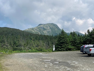
| The Summit of Mt Mansfield as viewed from Parking Lot A (end of Toll Road, a 4.5 mile drive up the mountain to this point) photo courtesy of Dave |
Our destination on our Anniversary, 30, June was the Highest Peak of Vermont.
There are about 5-6 different approaches up Mt Mansfield from what I've read. Some people take the Gondola to a trail that is rated difficult. I didn't want that because it's considered the steepest route I believe. I kind of wanted to try the 7 mile loop but that's also rated difficult and between the fact that this was my first mountain climb of 2023 combined with high humidity and heat (it was about 82 the day we climbed), we decided to drive the Toll Road (NOT cheap!!) to the last lot and pick up the Ridgeline trail aka Long Trail where it would be a 1.4 mile hike over a very rocky ridgeline and hump before it levels out a bit and you get to the actual summit. (Note: I've hiked other pieces of the Long Trail in Vermont....mostly in the southern/eastern region).
We started out at about 10: 30 am on the trail after listening to the guidelines at the Visitors Center which is at Parking Lot A, 4 miles up the mountain. The trail has ropes in spots indicating where to stay on the trail to avoid disturbing the alpine flora. All alpine flora over 4000 feet is considered endangered due to many hikers going off trail. Thankfully we found that hikers here were following the rules, unlike some we see (usually out of state tourists!) in the Adirondacks.
We arrived at the summit marker at about 12:30 pm. yes, it took 2 hours to hike only 1.4 miles. This mountain is HARD. The rocks were so slick in places due to the previous 3 days of rain! There were spots where I had to crawl on my hands and knees to get up and over OR sit and swing my legs over to get to the next piece of trail. Amazingly, I had no neck, head, or back pain!!
Here's the hike in photos:
 |
| The trailhead sign |
 |
| Warning about the arctic-alpine zone. |
 |
| beginning of trail is through woods nice and cool....and flat! |
 |
| Open ridgeline appears quickly...... ....see the summit in the background?? that's only 1. 3 miles away!! |
 |
| First overlook down onto the village of Stowe we've now hiked maybe .4 miles at this point |
 |
| the first cairn.....Dave made it up to part of the dark hump..... ....I quickly followed. This part wasn't too bad...... ......we were just starting to get sweaty. I had to remove my outer layer. |
Here comes the hard part (for me anyways.....to the right is a deep drop off....to the left is a narrow walk and another drop off......this was a tough part.... we didn't take a lot of photos through here as we had to concentrate.....
 |
| difficult piece of trail |
 |
| drop off to the left....this is what we saw.... the beautiful Green Mountains of Vermont |
 |
| look carefully in the center of pic: the little red things are the gondolas |
Hikers who take the gondolas from the base of the mountain ride to where the Cliff Trail picks up. The Cliff Trail is a shorter route but very steep. We met a few people who had taken this. This was to the right of us from the ridgeline to where we were almost to the summit.
 |
| fragile alpine flowers near the last 1/4 mile of ridgeline |
After sitting down to drink water and eat some snacks, we heard our names and turned around to see the younger couple from the Inn coming up and over the ridge onto the summit. It had taken them almost 3 hours to do their hike from the bottom.........we all celebrated!
And they were very kind to get a photo of us after we took one of them.
This is a high I will never forget. I thank God for my husband....he doesn't like heights nor rock climbing yet he did it. He's a keeper!
HAPPY ANNIVERSARY TO US!!
The rest of that day included (before the hike) a wonderful breakfast at the Inn where we celebrated the day with Mimosas made with the champagne my work colleagues gifted us with, and the orange juice the Innkeeper gave us.
After leaving MT Mansfield, we went back to the village for ice cream and then went back to the Inn for showers and relaxing with our books. We had a 6:30 pm reservation at this place and it was absolutely divine. It was so worth the money. dave had the Lobster Ravioli which included bread and salad and I had the Pesto Fettuccine which included bread and salad. And we ended the day with sharing this heavenly Limoncello Pie for dessert.


2 comments:
Hi Faith. What a beautiful hike! I love that you and Dave completed this challenging trail. Great pictures. So glad that you had this lovely getaway trip.
Oh wow what a great day you had. I don't think I could have coped with those heights.
Post a Comment